|
Back to
Top
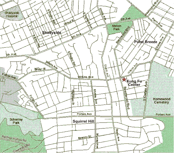
Directions to Pittsburgh Kung Fu
Center
From Fox Chapel:
Start out on
PA-28 Allegheny Valley Expressway.
Take Exit 6, Highland Park
Bridge (left exit) towards Aspinwall (PA-8 South). 0.1 miles
Merge
onto Highland Park Bridge. 0.6 miles
Take the PA-8
South/Washington Boulevard ramp. 0.2 miles
Merge onto Washington
Boulevard. 2.9 miles
After crossing Penn Avenue, Washington Boulevard
becomes Fifth Avenue. 0.2 miles
Turn left onto Beechwood Boulevard.
0.8 miles
Turn left onto Wilkins Avenue.
From Oakmont:
Start out on
Allegheny River Boulevard.
Turn left onto Washington Boulevard. 2.9
miles
After crossing Penn Avenue, Washington Boulevard becomes Fifth
Avenue. 0.2 miles
Turn left onto Beechwood Boulevard. 0.8 miles
Turn left onto Wilkins Avenue.
Back to
Top
From Homewood:
Start out
going Southwest on North Dallas Avenue (PA-380) towards Penn Avenue. 0.2
miles
North Dallas becomes South Dallas Avenue. 0.4 miles
Stay straight
to go onto Wilkins Avenue. 0.3 miles
From Wilkinsburg:
Start out heading North on Penn Avenue (PA-8) towards Downtown.
Turn left
onto South Dallas Avenue. 0.4 miles
Stay straight to go onto Wilkins
Avenue. 0.3 miles
Back to
Top
From Monroeville (I-376
West):
From the Parkway West (I-376) inbound towards Pittsburgh take
Exit 9 Edgewood/Swissvale.
Turn right onto South Braddock Avenue. 0.1 miles
Turn left onto Forbes Avenue. 0.8 miles
Turn right onto South Dallas
Avenue. 0.6 miles
Turn left onto Wilkins Avenue. 0.4 miles
From Edgewood:
Start out on
South Braddock Avenue heading North towards Penn Avenue.
Turn left onto
Forbes Avenue. 0.8 miles
Turn right onto South Dallas Avenue. 0.6 miles
Turn left onto Wilkins Avenue. 0.4 miles
From Squirrel Hill:
Start out on Murray Avenue
heading North towards Shadyside.
Turn right onto Wilkins Avenue. 0.3 miles
Back to
Top
From Greenfield:
Start
out on Greenfield Avenue heading towards Greenfield Bridge.
From West turn
left onto Ronald Street; from East stay straight to go onto Ronald Street.
Turn right onto Beechwood Boulevard. 0.5 miles
Turn left onto Forward
Avenue. 0.3 miles
Turn left onto Murray Avenue. 1.0 miles
Turn right
onto Wilkins Avenue. 0.3 miles
From Hazelwood:
Start out
going Northeast on Hazelwood Avenue towards Greenfield
Turn left onto
Beechwood Boulevard. 0.4 miles
Turn left onto Welfer Street. 0.1 miles
Turn right onto Murray Avenue. 1.4 miles
Turn right onto Wilkins Avenue.
0.3 miles
Back to
Top
From CMU, Pitt:
Start out
going East on Forbes Avenue towards Squirrel Hill
Turn left onto Beeler
Street. 0.4 miles
Turn slight right onto Wilkins Avenue. 0.7 miles
Bus Route: Catch any 67 bus (A. C. E. F. or J) on Forbes Avenue
and get off at the intersection of Wilkins and Beechwood.
From Shadyside:
Start out
going east on Fifth Avenue towards Wilkinsburg
Turn right onto Shady
Avenue. 0.7 miles
Turn left onto Wilkins Avenue. 0.2 miles
From Southside:
Start
out on East Carson Street heading towards 22nd Street.
Turn onto Birmingham
Bridge. 0.2 miles
Turn right onto Forbes Avenue. 2.0 miles
Turn left
onto Beeler Street. 0.4 miles
Turn slight right onto Wilkins Avenue. 0.7
miles
Back to
Top
From Downtown:
Via Forbes Avenue:
Start out going
East on Forbes Avenue towards Uptown. 2.0 miles
Stay on Forbes
Avenue through Oakland. 1.0 miles
Turn left onto Beeler Street.
0.4 miles
Turn slight right onto Wilkins Avenue. 0.7 miles
Via Parkway:
Start out going
Southwest on Grant Street towards First Avenue.
Take the I-376
East ramp towards Monroeville.0.3 miles
Merge onto US-22 E.3.7
miles
Follow directions from the Parkway (I-376) East below:
From I-376 East:
From the
Parkway (I-376) take Exit 8 Squirrel Hill/Homestead.
Turn left onto Forward
Avenue. 0.3 miles
Turn left onto Murrary Avenue. 1.0 miles
Turn right
onto Wilkins Avenue. 0.3 miles
Back to
Top
From Northside:
Start out going East on East Ohio Street.
Take the PA-28 North ramp towards
Etna. 0.2 miles
Merge onto PA-28 North. 0.9 miles
Turn rigth onto
31st Street Bridge. 0.5 miles
31st Street Bridge
becomes 31st Street. 0.1 miles
Turn left onto Liberty Avenue.
1.9 miles
Liberty Avenue becomes South Aiken Avenue. 0.6 miles
Turn
left onto Fifth Avenue. 0.6 miles
Turn right onto Shady Avenue. 0.7
miles
Turn left onto Wilkins Avenue. 0.2 miles
From the North Hills:
Start out going South on I-279
Take the I-579 South exit towards Veterans
Bridge. 1.5 miles
Take the ramp towards Oakland(I-376 East)/Monroeville.
0.3 miles
Merge onto Boulevard of the Allies. 1.4 miles
Turn slight
left onto Forbes Avenue. 1.6 miles
Turn left onto Beeler Street. 0.4 miles
Turn slight right onto Wilkins Avenue.
Back to
Top |